
General Information
Project Type
| Function / usage: |
Fortification wall |
|---|
Awards and Distinctions
| 1987 |
part of an ensemble
for registered users |
|---|---|
|
for registered users |
Location
| km | Name |
Technical Information
Dimensions
| width | ca. 5 m | |
| height | ca. 3 m | |
| length | ca. 63 km |
Chronology
| 142 — 163 | The northern Roman frontier in Britain is move north and the Antonine Wall is built as fortification. Previously, Hadrian's Wall was the border. By 163, the border is moved back again to Hadrian's Wall. |
|---|
Excerpt from Wikipedia
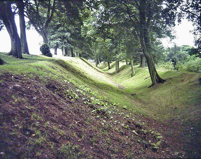
The Antonine Wall, known to the Romans as Vallum Antonini, was a turf fortification on stone foundations, built by the Romans across what is now the Central Belt of Scotland, between the Firth of Forth and the Firth of Clyde. Representing the northernmost frontier barrier of the Roman Empire, it spanned approximately 63 kilometres (39 miles) and was about 3 metres (10 feet) high and 5 metres (16 feet) wide. Lidar scans have been carried out to establish the length of the wall and the Roman distance units used. Security was bolstered by a deep ditch on the northern side. It is thought that there was a wooden palisade on top of the turf. The barrier was the second of two "great walls" created by the Romans in what the English once called Northern Britain. Its ruins are less evident than the better-known Hadrian's Wall to the south, primarily because the turf and wood wall has largely weathered away, unlike its stone-built southern predecessor.
Construction began in AD 142 at the order of Roman Emperor Antoninus Pius, and took about 12 years to complete. Antoninus Pius never visited Britain, whereas his predecessor Hadrian did. Pressure from the Caledonians may have led Antoninus to send the empire's troops further north. The Antonine Wall was protected by 16 forts with small fortlets between them; troop movement was facilitated by a road linking all the sites known as the Military Way. The soldiers who built the wall commemorated the construction and their struggles with the Caledonians in decorative slabs, twenty of which survive. The wall was abandoned only eight years after completion, and the garrisons relocated back to Hadrian's Wall. In 208 Emperor Septimius Severus re-established legions at the wall and ordered repairs; this has led to the wall being referred to as the Severan Wall. The occupation ended a few years later, and the wall was never fortified again. Most of the wall and its associated fortifications have been destroyed over time, but some remains are visible. Many of these have come under the care of Historic Scotland and the UNESCO World Heritage Committee.
Location and construction
Roman Emperor Antoninus Pius ordered the construction of the Antonine Wall around 142. Quintus Lollius Urbicus, governor of Roman Britain at the time, initially supervised the effort, which took about twelve years to complete. The wall stretches 63 kilometres (39 miles) from Old Kilpatrick in West Dunbartonshire on the Firth of Clyde to Carriden near Bo'ness on the Firth of Forth. The wall was intended to extend Roman territory and dominance by replacing Hadrian's Wall 160 kilometres (99 miles) to the south, as the frontier of Britannia. But while the Romans did establish many forts and temporary camps further north of the Antonine Wall in order to protect their routes to the north of Scotland, they did not conquer the Caledonians, and the Antonine Wall suffered many attacks. The Romans called the land north of the wall Caledonia, though in some contexts the term may refer to the whole area north of Hadrian's Wall.
The Antonine Wall was shorter than Hadrian's Wall and built of turf on a stone foundation, but it was still an impressive achievement. It was also a simpler fortification than Hadrian's Wall insofar as it did not have a subsidiary ditch system behind it to the south, as Hadrian's Wall did with its Vallum. The stone foundations and wing walls of the original forts on the Antonine Wall demonstrate that the original plan was to build a stone wall similar to Hadrian's Wall, but this was quickly amended. As built, the wall was typically a bank, about four metres (13 feet) high, made of layered turves and occasionally earth with a wide ditch on the north side, and a military way on the south. The Romans initially planned to build forts every 10 kilometres (6 miles), but this was soon revised to every 3.3 kilometres (2 miles), resulting in a total of nineteen forts along the wall. The best preserved but also one of the smallest forts is Rough Castle Fort. In addition to the forts, there are at least 9 smaller fortlets, very likely on Roman mile spacings, which formed part of the original scheme, some of which were later replaced by forts. The most visible fortlet is Kinneil, at the eastern end of the Wall, near Bo'ness.
There was once a remarkable Roman structure within sight of the Antonine Wall at Stenhousemuir. This was Arthur's O'on, a circular stone domed monument or rotunda, which may have been a temple, or a tropaeum, a victory monument. It was demolished for its stone in 1743, though a replica exists at Penicuik House.
Forts and Fortlets associated with the Antonine Wall from west to east: Bishopton, Old Kilpatrick, Duntocher, Cleddans, Castlehill, Bearsden, Summerston, Balmuildy, Wilderness Plantation, Cadder, Glasgow Bridge, Kirkintilloch, Auchendavy, Bar Hill, Croy Hill, Westerwood, Castlecary, Seabegs, Rough Castle, Camelon, Watling Lodge, Falkirk, Mumrills, Inveravon, Kinneil, Carriden The Bridgeness Slab - The easternmost distance slab
In addition to the line of the Wall itself there are a number of coastal forts both in the East (e.g. Inveresk) and West (Outerwards and Lurg Moor), which should be considered as outposts and/or supply bases to the Wall itself. In addition a number of forts farther north were brought back into service in the Gask Ridge area, including Ardoch, Strageath, Bertha (Perth) and probably Dalginross and Cargill.
RIB 2193. Distance Slab of the Second Legion George MacDonald calls in no. 6 in the 2nd edition of his book The Roman Wall in Scotland. He says it was found near the farm at Summerston on the banks of the Kelvin. It has been scanned and a video produced.
Recent research by Glasgow University has shown that the distance stones, stone sculptures unique to the Antonine Wall which were embedded in the wall to mark the lengths built by each legion, were brightly painted unlike their present bare appearance. These stones are preserved in the University's museum and are said to be the best-preserved examples of statuary from any Roman frontier. Several of the slabs have been analysed by various techniques including portable X-ray fluorescence (pXRF). Tiny remnants of paint have been detected by surface-enhanced Raman spectroscopy (SERS). Several of the distance slabs have been scanned and 3-D videos produced. There are plans to reproduce the slabs, both digitally and in real physical copies, with their authentic colours. A copy of the Bridgeness Slab has already been made and can be found in Bo'ness. It is also expected that lottery funding will allow replicas of distance markers to be placed along the length of the wall.
Abandonment
The wall was abandoned only eight years after completion, when the Roman legions withdrew to Hadrian's Wall in 162, and over time may have reached an accommodation with the Brythonic tribes of the area, whom they may have fostered as possible buffer states which would later become "The Old North". After a series of attacks in 197, the emperor Septimius Severus arrived in Scotland in 208 to secure the frontier, and repaired parts of the wall. Although this re-occupation only lasted a few years, the wall is sometimes referred to by later Roman historians as the Severan Wall. This led to later scholars like Bede mistaking references to the Antonine Wall for ones to Hadrian's Wall.
Post-Roman history
In the centuries since the Antonine Wall was abandoned, it has influenced the culture between the Forth and the Clyde.
Gildas and Bede
Writing in AD 730, Bede, following Gildas in his De Excidio et Conquestu Britanniae, mistakenly ascribes the construction of the Antonine Wall to the Britons in his Historia Ecclesiastica 1.12:
The islanders built the wall which they had been told to raise, not of stone, since they had no workmen capable of such a work, but of sods, made it of no use. Nevertheless, they carried it for many miles between the two bays or inlets of the sea of which we have spoken; to the end that where the protection of the water was wanting, they might use the rampart to defend their borders from the irruptions of the enemies. Of the work there erected, that is, of a rampart of great breadth and height, there are evident remains to be seen at this day [AD 730]. It begins at about two miles distance from the monastery of Aebbercurnig [Abercorn], west of it, at a place called in the Pictish language Peanfahel, but in the English tongue, Penneltun [Kinneil], and running westward, ends near the city of Aicluith [Dumbarton].
Bede associated Gildas' turf wall with the Antonine Wall. As for Hadrian's Wall, Bede again follows Gildas:
[the departing Romans] thinking that it might be some help to the allies [Britons], whom they were forced to abandon, constructed a strong stone wall from sea to sea, in a straight line between the towns that had been there built for fear of the enemy, where Severus also had formerly built a rampart.
Bede obviously identified Gildas' stone wall as Hadrian's Wall, but he sets its construction in the 5th century rather than the 120s, and does not mention Hadrian. And he would appear to have deduced that the ditch-and-mound barrier known as the Vallum (just to the south of, and contemporary with, Hadrian's Wall) was the rampart constructed by Severus. Many centuries would pass before just who built what became apparent.
Grim's Dyke
In medieval histories, such as the chronicles of John of Fordun, the wall is called Gryme's dyke. Fordun says that the name came from the grandfather of the imaginary king Eugenius son of Farquahar. This evolved over time into Graham's dyke – a name still found in Bo'ness at the wall's eastern end – and then linked with Clan Graham. Of note is that Graeme in some parts of Scotland is a nickname for the devil, and Gryme's Dyke would thus be the Devil's Dyke, mirroring the name of the Roman Limes in Southern Germany often called 'Teufelsmauer'. Grímr and Grim are bynames for Odin or Wodan, who might be credited with the wish to build earthworks in unreasonably short periods of time. This name is the same one found as Grim's Ditch several times in England in connection with early ramparts: for example, near Wallingford, Oxfordshire or between Berkhamsted (Herts) and Bradenham (Bucks). Other names used by antiquarians include the Wall of Pius and the Antonine Vallum, after Antoninus Pius. Hector Boece in his 1527 History of Scotland called it the "wall of Abercorn", repeating the story that it had been destroyed by Graham.
World Heritage status
The UK government's nomination of the Antonine Wall for World Heritage status to the international conservation body UNESCO was first officially announced in 2003. It has been backed by the Scottish Government since 2005 and by Scotland's then Culture Minister Patricia Ferguson since 2006. It became the UK's official nomination in late January 2007, and MSPs were called to support the bid anew in May 2007. The Antonine Wall was listed as an extension to the World Heritage Site "Frontiers of the Roman Empire" on 7 July 2008. Though the Antonine Wall is mentioned in the text, it does not appear on UNESCO's map of world heritage properties.
Historic Environment Scotland
Several individual sites along the line of the wall are in the care of Historic Scotland. These are at:
- Bar Hill Fort
- Bearsden Bath House
- Castlecary
- Croy Hill
- Dullatur
- Rough Castle
- Seabegs Wood
- Watling Lodge
- Westerwood, Cumbernauld
All sites are unmanned and open at all reasonable times.
Mapping the wall
The first capable effort to systematically map the Antonine Wall was undertaken in 1764 by William Roy, the forerunner of the Ordnance Survey. He provided accurate and detailed drawings of its remains, and where the wall has been destroyed by later development, his maps and drawings are now the only reliable record of it. Modern computer techniques like using GIS can now map the wall in 3-dimensions which makes it much easier to study for example how visible forts and fortlets were to their fellow soldiers along the wall.
Text imported from Wikipedia article "Antonine Wall" and modified on 22 July 2019 under the CC-BY-SA 3.0 license.
Participants
Currently there is no information available about persons or companies having participated in this project.
Relevant Web Sites


Relevant Publications
- (2017): The Antonine Wall's distance-slabs: LiDAR as metric survey. In: Journal of Roman Archeology, v. 30 ( 2017), pp. 447-468.
- : Return to normalcy? Building materials and the making of the Antonine Wall. In: Archaeological Journal, pp. 1-29.
- About this
data sheet - Structure-ID
10000486 - Published on:
18/03/2004 - Last updated on:
28/05/2021
Structurae cooperates with


